
The implementation of UAVs (Unmanned Aerial Vehicles) in various sectors, particularly industrial and scientific, is constantly increasing. Drones are flexible, adaptable, and facilitate many tasks that, were they to be undertaken by individuals, would require great amounts of time, energy and resources. Drones are often used as carriers for small, light measuring systems. These systems are generally used to identify and measure interesting landscapes such as large forest areas. Such systems therefore play a vital role in the gathering of data which are used by scientists and industrial researchers in various analyses. They need to be able to flexibly gather and analyze many varying parameters with little to no effort. As the environment is highly dynamic, characterized by many different natural disasters, the parameters need to be precisely and long-term documented and interpreted. “The laser scanners that have been produced thus far can be adapted for attachment on a drone but only a few scanning systems are designed specifically for this application. Furthermore, an integrated scan system with cameras has yet to be developed,” Prof. Dr. Alexander Reiterer from the Fraunhofer Institute for Physical Measurement Techniques IPM explains. As head of the Object and Shape Detection Department, he recognized the potential for such an integrated scan system early on and formed a partnership with Prof. Dr. Barbara Koch from the University of Freiburg. Together, they and their colleagues formed the project “MulDiScan: Geological Hazards – Better Evaluation Thanks to Better Environmental Data”, which was supported by the Sustainability Center Freiburg.
Three types of natural disasters were to be primarily inspected 1) hydrological events (e.g. heavy downpour), 2) geomorphological events (landslides or avalanches) and 3) biosphere events (e.g. forest fires). Prof Dr. Reiterer explains, that he and his team picked these three types as insufficient data from previous scanning procedures in these areas could be found. A further goal of this project was to develop a sensor system for the fast and precise measurement of large objects and structures. As Prof. Dr. Reiterer further explains, the development of a suitable system was far more valuable than the possible applications thereof. If an integrated system, which is easily and dynamically usable as a 3D-Data collection method, can be developed, then the application possibilities are endless.
For Prof. Koch, as Chair of the Remote Sensing and Landscape Information Systems Department of the University of Freiburg, the development of such a laser scan system was also promising as a tool for her analyses, especially in the forest inventory. Usually satellite images of forest areas are used for analyses such as recording vitality and other parameters of single trees but also of entire forests. The quality and resolution of such images are generally not sufficient enough for the level of detail that is required for parameter analyses. Images taken from planes or from satellites usually have significant time spans between them as well. Therefore, the growing rate of trees for example as indicated by the images, is not always up to date. If these data are recorded by a sensor system on a drone, researchers would be able to obtain new images every few weeks. This would allow for timely analyses of any actual changes in the environment caused by natural disasters or other extreme events.
The utilization of such a system is not restricted to research sectors: the industry also has great need of such a flexible system, especially in traffic-facility construction and road construction. The collection of construction area and construction progress data, including any possible vegetation on the terrain that could impede the progress, would be greatly simplified by such a system. Based on this realization, potential industrial partners such as STRABAG AG., were intrigued by the possible applications of the technology being developed by Dr. Reiterer and his colleagues.
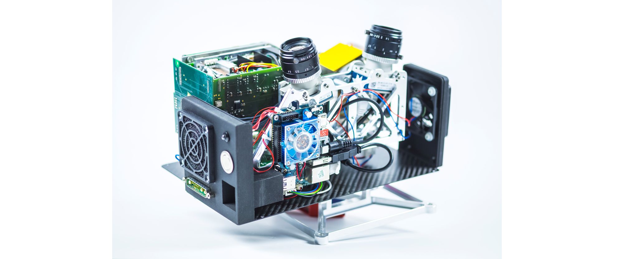
The completed system is comprised of an internal scan system, two cameras, and an internal storage unit plus a positioning system. Altogether, the unit weighs about 2.5 kilos (see Figures 01 and 04). Dr. Reiterer proudly reports how his team was able to come up with an initial concept within only a few months of the start of the project. They conducted a test flight of their first prototype attached to a small drone lent to them by Prof. Koch and realized, there was still a bit of work to be done on the system. Within the next two years they further tweaked their prototype to a successful so-called Version 0 form (see Figure 02). During the development of this new form, the team had more wiggle room in the design of the system. Legal regulations that had restricted the flight weight of drones in Germany were loosened. At the beginning of the project, an entire flying system (drone plus laser) could not weigh more than five kilos. A new law passed in 2017 increased this restriction to ten kilos.
The current prototype produces 30 profiles per second and up to 40,000 points per second. These distance measurements are formed upon the basis of highly precise light-term measurements, in which the time required for a light pulse to travel from a sender to an object and back to a detector is measured. When the drone flies over any area, a laser beam is deflected off of a special mirror in the unit which results in a profile-like scanning of the area and any structures within it. By fusing these data with various orientation and position information measured by the system whilst in the air, a 3D-depiction (a so-called point cloud) is formed. Another layer of information, namely the texture information, which is recorded by the cameras simultaneously as the scanning, is projected into the point cloud in order to create a realistic depiction (as shown in Figure 03). “It’s like a computer game,” grins Dr. Reiterer. “It’s as if you are walking through a virtual landscape.” This walk is not aimed at finding dragons and other magical beasts but instead, to better analyze the surroundings and to undertake a risk-assessment thereof.
Not only was a hardware prototype developed, but also a suitable software to go along with it. The software’s role is to process the data, which can be transferred from the scanner onto a PC per USB stick, in such a manner that it is easily accessible for the user. The goal thereby is to have this exchange of data from USB port on the scanner to the final USP port on the end user’s PC to be as smooth and uncomplicated as possible. The next step for the team is the transfer of technology and the prototypical development of a demonstrator. This version, with any improvements upon Version 0 that are necessary, will demonstrate the performance of the developed system and will prove its usability. Such a sensor system will most likely remain a niche product, considering that it is meant for highly specific consumers. As an important side note, this new technology is neither dangerous for humans nor for animals, as it uses an eye-safe laser. In fact, “the measuring systems are themselves sometimes in danger from birds of prey which like to attack the drones,” laughs Dr. Reiterer.
The results obtained throughout the MulDiScan project were already used as the basis for a different publically funded project. Started in September 2017, the researchers joined forces with French and Austrian colleagues in order to examine a further possible application of the measuring system. The project had the goal to collect ocean and river data. Upper surface reflections generally inhibit accurate sampling of such data but with the new measuring system, the researchers could map the ocean’s floor or river bottom, scanning directly through the water. The measuring system does need to be slightly altered for this examination, whereupon the researchers are working diligently. The three years research time of the MulDiScan project demanded the collaborative work of up to 20 colleagues with different competencies and expertise, including ten university students. The development of both a software and a measuring system made the multitude of experts a key to the successful completion of the project. Even six master’s students were able to complete their master’s theses on various aspects of the project. The team will continue to work on the software and collect more data for a databank in the remaining weeks of the funding period. In September 2018, the project partners will take leave of one another. They would be greatly interested in continuing their work however, in any future endeavors.